Obsah
Greasemonkey - Geocaching Map Enhancements (GME)

Geocaching Map Enhancements - jedno z nejlepších mapových rozhraní pro geokešing. Umožňuje snadno vyměňovat mapové podklady velké i malých map. Rychle je přepínat, přidávat nové a přidává i některé další možnosti jako měření vzdáleností, souřadnice a další a další
Instalace
První a důležité je mít v prohlížeči plugin (zásuvný modul) který umožňuje instalaci skriptů:
- Firefox - Greasemonkey plugin (nově (56+) i Tampermonkey plugin a Violent Monkey plugin) - jeden z nich ne všechny! Momentálně nejlíp funguje Tampermonkey FF56+.
- Chrome - Tampermonkey plugin
- Opera - Violent Monkey
- Edge (Microsoft)- Tampermonkey plugin
- ….
A nainstalovat si ho do prohlížeče.1)
Stáhnout skript lze potom odtud: ZDE. V případě, že máte nainstalované některé z výše uvedených rozšíření stačí kliknout vpravo nahoře na tlačítko install. A nebo prostě SEM
Když pak vstoupíte na velkou mapu na serveru Geocaching tak pokud vše funguje mělo by to vypadat zhruba takto možná podklad budete mít jiný. Pokud se toto nezobrazí je potřeba v levé boční liště map vstoupit do Set Map Preferences/Nastavení Map v levém dolním rohu vysouvací lišty. Tam pak musíte nastavit „Leaflet“ mapy (ty s tou větvičkou a lupením… a pak se vrátit do map a už by to mělo fungovat.
Důležité
- S přepnutými Google Mapami to opravdu nefunguje!!
- Pokud používáte GC Little Helper skript tak doporučuji v jeho nastavení vypnout vše co se týká nastavení MAP protože se to pak hádá s tímto skriptem!
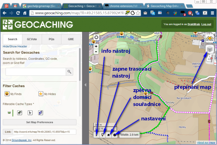 Obr. 1: Po implementaci pluginu a skriptu - Geocaching Map Enhancements
Možnosti
- Info nástroj - kliknutím se zapne/vypne (indikace modře). Při zapnutém - kliknutím kamkoliv do mapy zobrazí souřadnice a odkazy na další zajímavá místa.
- Skrýt cache - rychlé skrytí všech geocache na mapě jedním klikem (nově přidáno - symbol škrtlého oka)
- Trasovací nástroj - kliknutím se zapne/vypne (indikace modře) Při zapnutém klikáním do mapy umísťujete značky s trasou do mapy a dole v info boxu se zobrazuje naměřená vzdálenost. Kliknutím na již položený bod se objeví info s možností bod smazat nebo smazat vše.
- Zpět na domácí souřadnice - Domeček - kliknutím přemístí mapu na vaše zadané domácí souřadnice
- Nastavení - vstup do nastavení skriptu
Nastavení
Kliknutím na ozubené kolečko - se dostanete do nastavení skriptu kde se dá mnoho věcí nastavit.
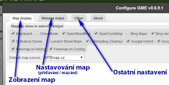 Obr. 2: Nastavení skriptu
- Map display - na této záložce se dá nastavit které mapy budou viditelné v přepínání map - které budou k dispozici. Navíc se tam dá nastavit i mapa která se natáhne jako první při startu map (Default map source). Po změnách v levém dolním rohu tlačítko Save pro uložení.
- Manage maps - tady se dají nepotřebné mapové podklady smazat2) popřípadě nahrát jiné nové. Přidávání údajů pro nové podklady ve formátu JSON. Přidání podkladu přes editační box Mapsource a potvrzení tlačítkem Add3)) a pak uložením tlačítkem Save. Stávající mapové podklady se dají i vyexportovat tlačítkem Export custom maps. Po změnách je nutné stisknout v levém dolním rohu tlačítko Save pro uložení jinak změny ztratíte!
- Other - další nastavení skriptu. Po změnách v levém dolním rohu tlačítko Save pro uložení.
Mapové podklady
Mapové podklady jsou vždy mezi dvěma složenými závorkami {..něco..} takže pokud chcete některý z mapových podkladů přidat tak zkopírujte některou složenou závorku včetně závorek - jen jednu(jeden řádek) a vložte jej v nastavení skriptu do políčka Mapsource na záložce Manage maps a klikněte na tlačítko Add pokud je vše vpořádku přiskočí mapa k zobrazeným a tlačítkem Save uložíte konfiguraci. Na mapě by se pak měla mapa objevit mezi mapami v přepínači map - napravo nahoře.
Pokud chcete mapu smazat tak na stejné záložce Manage maps zaškrkněte některou mapu a dejte Save pozor to co smažete už zpět nedostanete :)
Podklady
MTBmap.cz
{"alt":"MTBmap.cz","tileUrl":"http://tile.mtbmap.cz/mtbmap_tiles/{z}/{x}/{y}.png","minZoom":1,"maxZoom":18,"attribution":"","ignore":false}
Open Topo Map
{"alt":"OpenTopoMap","tileUrl":"https://{s}.tile.opentopomap.org/{z}/{x}/{y}.png","name":"otm","subdomains":"abc","ignore":false,"minZoom":5,"maxZoom":17}
OpenStreet Hike & Bike map
{"alt":"Hike&Bike", "tileUrl":"http://toolserver.org/tiles/hikebike/{z}/{x}/{y}.png", "attribution":"<a href='http://hikebikemap.de/'>Hike&Bike</a> render by Colin Marquardt from <a href='http://www.openstreetmap.org/'>OpenStreetMap</a> data, <a href='http://creativecommons.org/licenses/by-sa/2.0/'>CC-BY-SA</a>"}
Mapy.cz
{"alt":"Mapy.cz - Základní","tileUrl":"//mapserver.mapy.cz/base-m/{z}-{x}-{y}","minZoom":5,"maxZoom":18,"attribution":"© <a href='https://www.seznam.cz' target='_blank' rel='noopener'>Seznam.cz, a.s.</a>, © <a href='https://www.openstreetmap.org/copyright' target='_blank' rel='noopener'>OpenStreetMap</a>"}

{"alt":"Mapy.cz - Turistická","tileUrl":"//mapserver.mapy.cz/turist-m/{z}-{x}-{y}","minZoom":5,"maxZoom":18,"attribution":"© <a href='https://www.seznam.cz' target='_blank' rel='noopener'>Seznam.cz, a.s.</a>, © <a href='https://www.openstreetmap.org/copyright' target='_blank' rel='noopener'>OpenStreetMap</a>, © NASA"}

{"alt":"Mapy.cz - Dopravní","tileUrl":"//mapserver.mapy.cz/base-m/{z}-{x}-{y}?s=0.2&dm=Luminosity","minZoom":5,"maxZoom":18,"attribution":"© <a href='https://www.seznam.cz' target='_blank' rel='noopener'>Seznam.cz, a.s.</a>, © <a href='https://www.openstreetmap.org/copyright' target='_blank' rel='noopener'>OpenStreetMap</a>, © NASA"}

{"alt":"Mapy.cz - Letní","tileUrl":"//mapserver.mapy.cz/turist_aquatic-m/{z}-{x}-{y}","minZoom":5,"maxZoom":18,"attribution":"© <a href='http://www.seznam.cz' target='_blank'>Seznam.cz, a.s.</a>, © <a href='http://www.openstreetmap.org/copyright'>OpenStreetMap</a>, © NASA"}

{"alt":"Mapy.cz - Zimní","tileUrl":"//mapserver.mapy.cz/winter-m/{z}-{x}-{y}","minZoom":5,"maxZoom":18,"attribution":"© <a href='http://www.seznam.cz' target='_blank'>Seznam.cz, a.s.</a>, © <a href='http://www.openstreetmap.org/copyright'>OpenStreetMap</a>, © NASA"}

{"alt":"Mapy.cz - Zeměpisná","tileUrl":"//mapserver.mapy.cz/zemepis-m/{z}-{x}-{y}","minZoom":5,"maxZoom":18,"attribution":"© <a href='https://www.seznam.cz' target='_blank' rel='noopener'>Seznam.cz, a.s.</a>, © <a href='https://www.openstreetmap.org/copyright' target='_blank' rel='noopener'>OpenStreetMap</a>, © NASA"}

{"alt":"Mapy.cz - Letecká","tileUrl":"//mapserver.mapy.cz/bing/{z}-{x}-{y}","minZoom":5,"maxZoom":20,"attribution":"3. 7. 2015, © <a href='https://www.seznam.cz' target='_blank' rel='noopener'>Seznam.cz, a.s.</a>, © <a href='//www.basemap.at' target='_blank'>www.basemap.at</a>, © <a href='https://www.microsoft.com/maps/assets/docs/terms.aspx' target='_blank'>Microsoft Corporation</a>, © <a href='https://www.openstreetmap.org/copyright' target='_blank' rel='noopener'>OpenStreetMap</a>"}

{"alt":"Mapy.cz - Letecká '15","tileUrl":"//mapserver.mapy.cz/ophoto1415-m/{z}-{x}-{y}","minZoom":5,"maxZoom":19,"attribution":"© <a href='http://www.seznam.cz' target='_blank'>Seznam.cz, a.s.</a>, © <a href='http://eox.at/' target='_blank'>EOX IT Services GmbH</a>, © <a href='http://www.openstreetmap.org/copyright' target='_blank'>OpenStreetMap</a>"}

{"alt":"Mapy.cz - Letecká '12","tileUrl":"//mapserver.mapy.cz/ophoto1012-m/{z}-{x}-{y}","minZoom":5,"maxZoom":19,"attribution":"© <a href='http://www.seznam.cz' target='_blank'>Seznam.cz, a.s.</a>, © GEODIS BRNO,s.r.o."}

{"alt":"Mapy.cz - Letecká '06","tileUrl":"//mapserver.mapy.cz/ophoto0406-m/{z}-{x}-{y}","minZoom":5,"maxZoom":19,"attribution":"2004 - 2006, © <a href='https://www.seznam.cz' target='_blank' rel='noopener'>Seznam.cz, a.s.</a>, © <a href='//www.basemap.at' target='_blank'>www.basemap.at</a>, © <a href='https://www.microsoft.com/maps/assets/docs/terms.aspx' target='_blank'>Microsoft Corporation</a>, © <a href='https://www.openstreetmap.org/copyright' target='_blank' rel='noopener'>OpenStreetMap</a>"}

{"alt":"Mapy.cz - Letecká '03","tileUrl":"//mapserver.mapy.cz/ophoto0203-m/{z}-{x}-{y}","minZoom":5,"maxZoom":19,"attribution":"2001 - 2003, © <a href='https://www.seznam.cz' target='_blank' rel='noopener'>Seznam.cz, a.s.</a>, © <a href='//www.basemap.at' target='_blank'>www.basemap.at</a>, © <a href='https://www.microsoft.com/maps/assets/docs/terms.aspx' target='_blank'>Microsoft Corporation</a>, © <a href='https://www.openstreetmap.org/copyright' target='_blank' rel='noopener'>OpenStreetMap</a>"}

{"alt":"Mapy.cz - Z 19. století","tileUrl":"//mapserver.mapy.cz/army2-m/{z}-{x}-{y}","minZoom":5,"maxZoom":15,"attribution":"© 2nd Military Survey, Austrian State Archive, © MŽP ČR, © UJEP"}
Overlaye - překryvy
{"alt":"Mapy.cz - Popisky","tileUrl":"//mapserver.mapy.cz/hybrid-sparse-m/{z}-{x}-{y}","minZoom":5,"maxZoom":20,"attribution":"© <a href='http://www.seznam.cz' target='_blank'>Seznam.cz, a.s.</a>","overlay":true}

{"alt":"Mapy.cz - Popisky a cesty","tileUrl":"//mapserver.mapy.cz/hybrid-base-m/{z}-{x}-{y}","minZoom":5,"maxZoom":20,"attribution":"© <a href='http://www.seznam.cz' target='_blank'>Seznam.cz, a.s.</a>","overlay":true}

{"alt":"Mapy.cz - Popisky a trasy","tileUrl":"//mapserver.mapy.cz/hybrid-turist-m/{z}-{x}-{y}","minZoom":5,"maxZoom":20,"attribution":"© <a href='http://www.seznam.cz' target='_blank'>Seznam.cz, a.s.</a>","overlay":true}
Kompass mapa
{"alt":"Kompass","tileUrl":"http://ec2.cdn.ecmaps.de/WmsGateway.ashx.jpg?Experience=kompass&MapStyle=KOMPASS%20Touristik&TileX={x}&TileY={y}&ZoomLevel={z}","minZoom":6,"maxZoom":15,"attribution":"Kompass","ignore":false}
Slovenské mapy
{"alt":"Freemap Slovakia Hiking","tileUrl":"http://t{s}.freemap.sk/T/{z}/{x}/{y}.jpeg","attribution":"Map © <a href='http://www.freemap.sk/'>Freemap Slovakia</a>, data © <a href='http://openstreetmap.org'>OpenStreetMap</a> contributors","subdomains":"1234","minZoom":8,"maxZoom":16,"ignore":false}
{"alt":"Freemap Slovakia Bicycle","tileUrl":"http://t{s}.freemap.sk/C/{z}/{x}/{y}.jpeg","attribution":"Map © <a href='http://www.freemap.sk/'>Freemap Slovakia</a>, data © <a href='http://openstreetmap.org'>OpenStreetMap</a> contributors","subdomains":"1234","minZoom":8,"maxZoom":16,"ignore":false}
{"alt":"Freemap Slovakia Car","tileUrl":"http://t{s}.freemap.sk/A/{z}/{x}/{y}.jpeg","attribution":"Map © <a href='http://www.freemap.sk/'>Freemap Slovakia</a>, data © <a href='http://openstreetmap.org'>OpenStreetMap</a> contributors","subdomains":"1234","minZoom":8,"maxZoom":16,"ignore":false}
Mapquest mapy
{"alt":"MapQuest","tileUrl":"https://otile{s}-s.mqcdn.com/tiles/1.0.0/osm/{z}/{x}/{y}.jpg","name":"mpqosm","subdomains":"1234","ignore":true}
{"alt":"MapQuest Aerial","tileUrl":"https://otile{s}-s.mqcdn.com/tiles/1.0.0/sat/{z}/{x}/{y}.jpg","name":"mpqa","subdomains":"1234","ignore":true}
Bing Microsoft mapy
{"alt":"Bing Maps","tileUrl":"https://ecn.t{s}.tiles.virtualearth.net/tiles/r{q}?g=864&mkt=en-gb&lbl=l1&stl=h&shading=hill&n=z","subdomains":"0123","minZoom":1,"maxZoom":20,"attribution":"<a href='https://www.bing.com/maps/'>Bing</a> map data copyright Microsoft and its suppliers","name":"bingmap","ignore":true}
{"alt":"Bing Aerial View","tileUrl":"https://ecn.t{s}.tiles.virtualearth.net/tiles/a{q}?g=737&n=z","subdomains":"0123","minZoom":1,"maxZoom":20,"attribution":"<a href='https://www.bing.com/maps/'>Bing</a> map data copyright Microsoft and its suppliers","name":"bingaerial","ignore":true}
Open Street mapy
{"alt":"OpenStreetMap","tileUrl":"https://{s}.tile.openstreetmap.org/{z}/{x}/{y}.png","name":"osm","subdomains":"abc","ignore":false}
{"alt":"OpenCycleMap","tileUrl":"https://tile.thunderforest.com/cycle/{z}/{x}/{y}.png","name":"ocm","ignore":false}
Overlay - překryv
{"alt":"Hillshading","tileUrl":"https://toolserver.org/~cmarqu/hill/{z}/{x}/{y}.png","attribution":"Hillshading by <a\t href='https://wiki.openstreetmap.org/wiki/Hike_%26_Bike_Map'>Colin Marquardt</a> from NASA SRTM data","overlay":true,"ignore":false}
Google mapy
{"alt":"Google Maps","tileUrl":"https://mt.google.com/vt?&x={x}&y={y}&z={z}","name":"googlemaps","attribution":"<a href='https://maps.google.com/'>Google</a> Maps","subdomains":"1234","tileSize":256,"maxZoom":22,"ignore":false}
{"alt":"Google Satellite","tileUrl":"https://mt.google.com/vt?lyrs=s&x={x}&y={y}&z={z}","name":"googlemapssat","attribution":"<a href='https://maps.google.com/'>Google</a> Maps Satellite","subdomains":"1234","tileSize":256,"maxZoom":22,"ignore":false}
Overlay - překryv
{"alt":"Google labels","tileUrl":"http://mt1.google.com/vt/lyrs=h@218000000&hl=en&src=app&x={x}&y={y}&z={z}&s=","overlay":true,"attribution":"<a href='http://maps.google.com/'>Google Maps</a>","ignore":false}
ESRI mapy
{ "alt": "Esri DeLorme", "name":"esridelorm", "tileUrl":"http://server.arcgisonline.com/ArcGIS/rest/services/Specialty/DeLorme_World_Base_Map/MapServer/tile/{z}/{y}/{x}", "attribution":"Tiles © Esri — Copyright: \u00a92012 DeLorme", "maxZoom":11 }
{ "alt": "Esri NatGeoWorldMap", "name":"esrinategeo", "tileUrl":"http://services.arcgisonline.com/ArcGIS/rest/services/NatGeo_World_Map/MapServer/tile/{z}/{y}/{x}", "attribution":"Tiles © Esri — National Geographic, Esri, DeLorme, NAVTEQ, UNEP-WCMC, USGS, NASA, ESA, METI, NRCAN, GEBCO, NOAA, iPC" }
{ "alt": "Esri OceanBasemap", "name":"esriocean", "tileUrl":"http://services.arcgisonline.com/ArcGIS/rest/services/Ocean_Basemap/MapServer/tile/{z}/{y}/{x}", "attribution":"Tiles © Esri — Sources: GEBCO, NOAA, CHS, OSU, UNH, CSUMB, National Geographic, DeLorme, NAVTEQ, and Esri", "maxZoom":11 }
{ "alt": "Esri WorldImagery", "name":"esriimagy", "tileUrl":"http://server.arcgisonline.com/ArcGIS/rest/services/World_Imagery/MapServer/tile/{z}/{y}/{x}", "attribution":"Tiles © Esri — Source: Esri, i-cubed, USDA, USGS, AEX, GeoEye, Getmapping, Aerogrid, IGN, IGP, UPR-EGP, and the GIS User Community" }
{ "alt": "Esri WorldStreetMap", "name":"esriworld", "tileUrl":"http://server.arcgisonline.com/ArcGIS/rest/services/World_Street_Map/MapServer/tile/{z}/{y}/{x}", "attribution":"Tiles © Esri" }
{ "alt": "Esri WorldTopoMap", "name":"esritopo", "tileUrl":"http://server.arcgisonline.com/ArcGIS/rest/services/World_Topo_Map/MapServer/tile/{z}/{y}/{x}", "attribution":"Tiles © Esri — Esri, DeLorme, NAVTEQ, TomTom, Intermap, iPC, USGS, FAO, NPS, NRCAN, GeoBase, Kadaster NL, Ordnance Survey, Esri Japan, METI, Esri China (Hong Kong), and the GIS User Community" }
ČUZK mapy
{"alt":"ČUZK - 1:10000","tileUrl":"http://geoportal.cuzk.cz/WMS_ZM10_PUB/WMService.aspx","crs":"EPSG:4326","layers":"GR_ZM10","format":"image/png","transparent":false,"attribution":"© Český úřad zeměměřický a katastrální","overlay":false,"ignore":false,"minZoom":15,"maxZoom":17}
{"alt":"ČUZK - Topografická","tileUrl":"http://ags.cuzk.cz/arcgis/services/zmwm/MapServer/WMSServer","crs":"EPSG:3857","layers":"0","format":"image/png","transparent":false,"attribution":"© Český úřad zeměměřický a katastrální","overlay":false,"ignore":false,"minZoom":10,"maxZoom":19}
{"alt":"ČUZK - Satelitní","tileUrl":"http://ags.cuzk.cz/arcgis/services/ortofoto_wm/MapServer/WMSServer","crs":"EPSG:3857","layers":"0","format":"image/png","transparent":false,"attribution":"© Český úřad zeměměřický a katastrální","overlay":false,"ignore":false,"minZoom":10,"maxZoom":20}
{"alt":"ČUZK - Jen terén","tileUrl":"http://ags.cuzk.cz/arcgis2/services/dmr5g/ImageServer/WMSServer","crs":"EPSG:4326","layers":"dmr5g:GrayscaleHillshade","format":"image/png","transparent":false,"attribution":"© Český úřad zeměměřický a katastrální","overlay":false,"ignore":false,"minZoom":10,"maxZoom":20}
Overlay - překryv
{"alt":"ČUZK - Stínování","tileUrl":"http://ags.cuzk.cz/arcgis2/services/dmr5g/ImageServer/WMSServer","crs":"EPSG:4326","layers":"dmr5g:GrayscaleHillshade","format":"image/png","transparent":false,"attribution":"© Český úřad zeměměřický a katastrální","opacity":"0.5","overlay":true,"ignore":false,"minZoom":10,"maxZoom":20}
CENIA Mapy (nic moc kvalita)
{"alt":"CENIA - II. voj. mapování","tileUrl":"http://geoportal.gov.cz/ArcGIS/services/CENIA/cenia_rt_II_vojenske_mapovani/MapServer/WMSServer","crs":"EPSG:4326","layers":"0","format":"image/jpeg","transparent":false,"attribution":"© CENIA","overlay":false,"ignore":false,"minZoom":9,"maxZoom":16}
{"alt":"CENIA - III. voj. mapování","tileUrl":"http://geoportal.gov.cz/ArcGIS/services/CENIA/cenia_rt_III_vojenske_mapovani/MapServer/WMSServer","crs":"EPSG:4326","layers":"0","format":"image/jpeg","transparent":false,"attribution":"© CENIA","overlay":false,"ignore":false,"minZoom":9,"maxZoom":16}
{"alt":"CENIA - Vojenská","tileUrl":"http://geoportal.gov.cz/ArcGIS/services/CENIA/cenia_rt_RETM/MapServer/WMSServer","crs":"EPSG:4326","layers":"0,1,2,3,4,5","format":"image/jpeg","transparent":false,"attribution":"© Geografická služba AČR","overlay":false,"minZoom":8,"maxZoom":16}
ArcGis a WMLabs
{"alt":"ArcGis - Topografická","tileUrl":"https://services.arcgisonline.com/ArcGIS/rest/services/World_Topo_Map/MapServer/tile/{z}/{y}/{x}.png","attribution":"© Esri","subdomains":"abc","ignore":false}
{"alt":"ArcGis - Satelitní","tileUrl":"https://services.arcgisonline.com/ArcGIS/rest/services/World_Imagery/MapServer/tile/{z}/{y}/{x}.png","attribution":"© Esri","subdomains":"abc","maxZoom":17,"ignore":false}
{"alt":"WMLabs - Cykloturistická", "tileUrl":"http://{s}.tiles.wmflabs.org/hikebike/{z}/{x}/{y}.png", "subdomains": "abc", "attribution":"© <a href='http://www.openstreetmap.org/copyright'>OpenStreetMap</a>"}
Overlay - překryv
{"alt":"WMLabs - Stínování terénu", "tileUrl":"http://{s}.tiles.wmflabs.org/hillshading/{z}/{x}/{y}.png", "subdomains": "abc", "attribution":"Hillshading by <a href='https://wiki.openstreetmap.org/wiki/Hike_%26_Bike_Map'>Colin Marquardt</a> from NASA SRTM data", "overlay": true}
Směs dalších map
{"alt":"Map1.EU","tileUrl":"http://beta.map1.eu/tiles/{z}/{x}/{y}.jpg","minZoom":5,"maxZoom":15,"attribution":"Maps from Map1.EU and contributors CC-BY-SA","ignore":false}
{"alt":"ClWebMap","tileUrl":"http://static2.clweb.cz/mps/mapa_cz/zakladni/{z}/{x}/{x}_{y}.gif","name":"clw","ignore":false}
{"alt":"Toursprung","tileUrl":"http://tile02-cdn.maptoolkit.net/terrain/{z}/{x}/{y}.png","minZoom":2,"maxZoom":17,"attribution":"OpenStreetMap NPE","ignore":false}
{"alt":"London Street Maps","tileUrl":"https://ecn.t{s}.tiles.virtualearth.net/tiles/r{q}?g=864&productSet=mmCB","subdomains":"0123","minZoom":14,"maxZoom":17,"attribution":"<a href='https://www.bing.com/maps/'>Bing</a> map data copyright Microsoft and its suppliers","name":"binglondon","ignore":true}
{ "alt": "Stamen Terrain", "name":"stamterrain", "tileUrl":"http://{s}.tile.stamen.com/terrain/{z}/{x}/{y}.png", "attribution":"Map tiles by <a href='http://stamen.com'>Stamen Design</a>, <a href='http://creativecommons.org/licenses/by/3.0'>CC BY 3.0</a> — Map data © <a href='http://openstreetmap.org'>OpenStreetMap</a> contributors, <a href='http://creativecommons.org/licenses/by-sa/2.0/'>CC-BY-SA</a>", "subdomains":"abcd", "minZoom":4, "maxZoom":18 }
{ "alt": "Stamen Toner", "name":"stamtoner", "tileUrl":"http://{s}.tile.stamen.com/toner/{z}/{x}/{y}.png", "attribution":"Map tiles by <a href='http://stamen.com'>Stamen Design</a>, <a href='http://creativecommons.org/licenses/by/3.0'>CC BY 3.0</a> — Map data © <a href='http://openstreetmap.org'>OpenStreetMap</a> contributors, <a href='http://creativecommons.org/licenses/by-sa/2.0/'>CC-BY-SA</a>", "subdomains":"abcd", "minZoom":0, "maxZoom":20 }
{ "alt": "Stamen Watercolor", "name":"stamwater", "tileUrl":"http://{s}.tile.stamen.com/watercolor/{z}/{x}/{y}.png", "attribution":"Map tiles by <a href='http://stamen.com'>Stamen Design</a>, <a href='http://creativecommons.org/licenses/by/3.0'>CC BY 3.0</a> — Map data © <a href='http://openstreetmap.org'>OpenStreetMap</a> contributors, <a href='http://creativecommons.org/licenses/by-sa/2.0/'>CC-BY-SA</a>", "subdomains":"abcd", "minZoom":3, "maxZoom":16 }
{ "alt": "Thunderforest Landscape", "name":"ocmlandsc", "tileUrl":"http://{s}.tile3.opencyclemap.org/landscape/{z}/{x}/{y}.png", "attribution":"© <a href='http://www.opencyclemap.org'>OpenCycleMap</a>, <a href='http://openstreetmap.org'>OpenStreetMap</a> contributors, <a href='http://creativecommons.org/licenses/by-sa/2.0/'>CC-BY-SA</a>" }
{ "alt": "Thunderforest Transport", "name":"ocmtransp", "tileUrl":"http://{s}.tile2.opencyclemap.org/transport/{z}/{x}/{y}.png", "attribution":"© <a href='http://www.opencyclemap.org'>OpenCycleMap</a>, <a href='http://openstreetmap.org'>OpenStreetMap</a> contributors, <a href='http://creativecommons.org/licenses/by-sa/2.0/'>CC-BY-SA</a>" }
{ "alt": "London Street Maps", "tileUrl":"https://ecn.t{s}.tiles.virtualearth.net/tiles/r{q}?g=864&productSet=mmCB", "subdomains":"0123", "minZoom":14, "maxZoom":17, "attribution":"<a href='https://www.bing.com/maps/'>Bing</a> map data copyright Microsoft and its suppliers", "name":"binglondon", "ignore":true }
Overlaye - překryvy (souhrn)
{"alt":"Google labels","tileUrl":"http://mt1.google.com/vt/lyrs=h@218000000&hl=en&src=app&x={x}&y={y}&z={z}&s=","overlay":true,"attribution":"<a href='http://maps.google.com/'>Google Maps</a>","ignore":false}
{"alt":"Hillshading","tileUrl":"https://toolserver.org/~cmarqu/hill/{z}/{x}/{y}.png","attribution":"Hillshading by <a\t href='https://wiki.openstreetmap.org/wiki/Hike_%26_Bike_Map'>Colin Marquardt</a> from NASA SRTM data","overlay":true,"ignore":false}
{ "alt": "Mapy.cz letecké popisky", "tileUrl":"http://m{s}.mapserver.mapy.cz/hybrid-m/{z}-{x}-{y}", "minZoom":5, "maxZoom":20, "subdomains":"1234", "attribution":"<img src='http://mapy.cz/img/logo-small.svg' /> * Seznam.cz,a.s, * GEODIS BRNO,s.r.o.", "overlay":true, "ignore":false }
{ "alt": "Veřejná doprava", "name":"ptl", "tileUrl":"http://openptmap.org/tiles/{z}/{x}/{y}.png", "attribution":"Public Transport Lines\u00a9 <a href='http://openptmap.org/' target='_blank'>OpenPTMap</a>", "tileSize":256, "minZoom":0, "maxZoom":17, "overlay":true }
{"alt":"WMLabs - Stínování terénu", "tileUrl":"http://{s}.tiles.wmflabs.org/hillshading/{z}/{x}/{y}.png", "subdomains": "abc", "attribution":"Hillshading by <a href='https://wiki.openstreetmap.org/wiki/Hike_%26_Bike_Map'>Colin Marquardt</a> from NASA SRTM data", "overlay": true}
{"alt":"ČUZK - Stínování","tileUrl":"http://ags.cuzk.cz/arcgis2/services/dmr5g/ImageServer/WMSServer","crs":"EPSG:4326","layers":"dmr5g:GrayscaleHillshade","format":"image/png","transparent":false,"attribution":"© Český úřad zeměměřický a katastrální","opacity":"0.5","overlay":true,"ignore":false,"minZoom":10,"maxZoom":20}
{"alt":"WayMarkedTrail ","tileUrl":"http://tile.waymarkedtrails.org/hiking/{z}/{x}/{y}.png ","name":"wmt","overlay":true,"ignore":false}